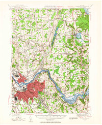
1954 Map of Schenectady
USGS Topo · Published 1957About this map
The industrial and transportation heart of the Mohawk Valley centers on Schenectady and its neighbors during the mid-1950s. The city's dense urban grid is flanked by Scotia and Rotterdam, while the Mohawk River and the Erie Canal define the southern landscape. This period shows a region in transition, where the historical infrastructure of the New York Central and Delaware and Hudson railroads intersects with growing residential developments in Niskayuna and Clifton Park. To the north, the terrain rises toward Malta Ridge, with the long, narrow Ballston Lake and the circular Round Lake serving as prominent landmarks. Local history is preserved through dozens of numbered school districts, such as School No 7 and School No 10, alongside established institutions like the Schenectady County Airport and the Nott Terrace High Sch.
Find a feature on this map
83 named features on this map. Tap any name to fly to it.
Don’t see what you’re looking for? This feature index may not catch every label — zoom into the map to look around manually.
Map Details
Editions of this 1954 Schenectady Map
This is the sole edition of this map. No revisions or reprints were ever made.
Other maps of this area

1893 · Cohoes
USGS Topo · 1:62,500

1893 · Troy
USGS Topo · 1:62,500

1893 · Schenectady
USGS Topo · 1:62,500

1893 · Albany
USGS Topo · 1:62,500

1895 · Troy
USGS Topo · 1:62,500

1895 · Cohoes
USGS Topo · 1:62,500

1895 · Albany
USGS Topo · 1:62,500

1895 · Schenectady
USGS Topo · 1:62,500

1895 · Amsterdam
USGS Topo · 1:62,500

1898 · Schenectady
USGS Topo · 1:62,500