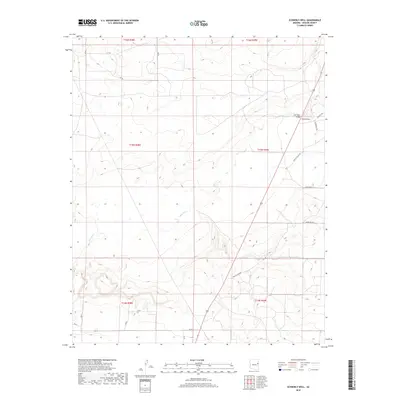
2018 Map of Schnebly Well
USGS Topo · Published 2018About this map
Schnebly Well serves as a primary landmark in this corner of Apache County, situated near the modern intersection of several desert roads. The course of the Zuni River winds across the landscape, crossing under the Zuni Wash Bridge in the northeastern quadrant. This area is characterized by low-lying drainages and isolated high points like Twin Peaks and Mountain Vw, reflecting the arid geography of eastern Arizona. The map documents a network of rural routes including Bonito Valley Rd, Appaloosa Trl, and Gunsite Way, which provide access through the township and range divisions. These features illustrate the sparse settlement and cattle-country infrastructure typical of the region in the early 21st century.
Find a feature on this map
25 named features on this map. Tap any name to fly to it.
Don’t see what you’re looking for? This feature index may not catch every label — zoom into the map to look around manually.
Map Details
Editions of this 2018 Schnebly Well Map
This is the sole edition of this map. No revisions or reprints were ever made.
Other maps of this area

1886 · St Johns
USGS Topo · 1:250,000

1892 · St Johns
USGS Topo · 1:250,000

1954 · Saint Johns
USGS Topo · 1:250,000

1955 · Wolford Springs 3 NW
USGS Topo · 1:24,000

1955 · Wolford Springs 3 SW
USGS Topo · 1:24,000

1957 · Saint Johns
USGS Topo · 1:250,000

1958 · Saint Johns
USGS Topo · 1:250,000

1962 · Saint Johns
USGS Topo · 1:250,000
1974 · St. Johns North
USGS Topo · 1:24,000
1977 · Ceadro Spring
USGS Topo · 1:24,000