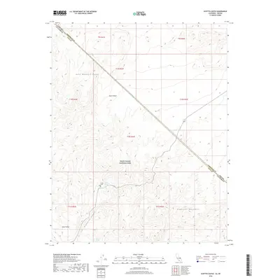
2018 Map of Scottys Castle
USGS Topo · Published 2018About this map
Scottys Castle stands as a distinct architectural landmark within the northern reaches of Death Valley National Park, situated where the Gold Mountain Range meets the Grapevine Mountains. This 2018 survey documents the vital water sources that sustained habitation in this arid landscape, including Scottys Grapevine Spring and Surprise Springs further south. The map illustrates the dramatic transition from the high desert terrain of the Mojave Desert down into the floor of Death Valley via the steep descent of Grapevine Canyon. A prominent diagonal boundary marks the state line between Nevada and California, specifically dividing Esmeralda and Inyo counties. The spatial relationship between these springs and the isolated homestead highlights the extreme dependence on localized hydrography in the high desert of the early 21st century.
Find a feature on this map
18 named features on this map. Tap any name to fly to it.
Don’t see what you’re looking for? This feature index may not catch every label — zoom into the map to look around manually.
Map Details
Editions of this 2018 Scottys Castle Map
This is the sole edition of this map. No revisions or reprints were ever made.
Other maps of this area

1908 · Lida
USGS Topo · 1:250,000

1908 · Ballarat
USGS Topo · 1:250,000

1913 · Lida
USGS Topo · 1:250,000

1913 · Ballarat
USGS Topo · 1:250,000

1948 · Death Valley
USGS Topo · 1:250,000

1954 · Death Valley
USGS Topo · 1:250,000

1954 · Goldfield
USGS Topo · 1:250,000

1955 · Goldfield
USGS Topo · 1:250,000

1956 · Death Valley
USGS Topo · 1:250,000

1957 · Death Valley
USGS Topo · 1:250,000