
1944 Map of Scraggly Lake
USGS Topo · Published 1944About this map
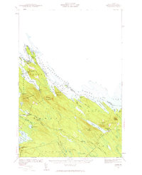
Baskahegan Lake and the surrounding timberlands of northern Washington County dominate this 1941 survey, revealing a landscape defined by an intricate network of waterways and wetlands. The map details the transition from the sprawling Big Bog and Crabtree Bog into the more mountainous terrain to the south, where Musquash Mountain and Mt Delight rise above the basin. The topographical data, compiled by surveyors F. F. Blankenbaker and L. H. Corn, captures the region just before mid-century shifts in land management.
Find a feature on this map
95 named features on this map. Tap any name to fly to it.
Don’t see what you’re looking for? This feature index may not catch every label — zoom into the map to look around manually.
Map Details
Editions of this 1944 Scraggly Lake Map
This is the sole edition of this map. No revisions or reprints were ever made.
Other maps of this area

1931 · Springfield
USGS Topo · 1:48,000

1932 · Nicatous Lake
USGS Topo · 1:48,000

1934 · Nicatous Lake
USGS Topo · 1:62,500

1934 · Springfield
USGS Topo · 1:62,500

1940 · Danforth
USGS Topo · 1:62,500

1940 · Waite
USGS Topo · 1:62,500
1940 · Forest
USGS Topo · 1:62,500

1941 · Danforth
USGS Topo · 1:62,500

1941 · Scraggly Lake
USGS Topo · 1:62,500

1941 · Big Lake
USGS Topo · 1:62,500