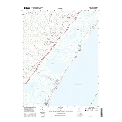
2016 Map of Sea Isle City
USGS Topo · Published 2016About this map
Sea Isle City and Ludlam Beach anchor this coastal landscape, showing the dense grid of a developed Jersey Shore community alongside a complex network of marshes and tidal waterways. The barrier island is separated from the mainland by a labyrinth of channels including Ludlam Bay, Townsend Sound, and Corson Sound, connected to the Atlantic through the prominent Corson Inlet. On the mainland, the Garden State Parkway serves as a modern spine, passing through inland settlements like Seaville, Ocean View, and Palermo. Genealogy researchers can find Woodland Cem near the edge of the Great Cedar Swamp, while local history interests may note the location of the Bascule Bridge connecting Strathmere to the mainland. The contrast between the rigid urban planning of the beach resorts and the erratic, natural drainage of Cedar Swamp Creek illustrates the dual nature of Cape May County geography.
Find a feature on this map
138 named features on this map. Tap any name to fly to it.
Don’t see what you’re looking for? This feature index may not catch every label — zoom into the map to look around manually.
Map Details
Editions of this 2016 Sea Isle City Map
This is the sole edition of this map. No revisions or reprints were ever made.
Other maps of this area

1884 · Sea Isle
USGS Topo · 1:62,500

1888 · Dennisville
USGS Topo · 1:62,500

1888 · Sea Isle
USGS Topo · 1:62,500

1890 · Great Egg Harbor
USGS Topo · 1:62,500

1890 · Tuckahoe
USGS Topo · 1:62,500

1893 · Great Egg Harbor
USGS Topo · 1:62,500

1893 · Tuckahoe
USGS Topo · 1:62,500

1894 · Dennisville
USGS Topo · 1:62,500

1894 · Sea Isle
USGS Topo · 1:62,500

1918 · Great Egg Harbor
USGS Topo · 1:62,500