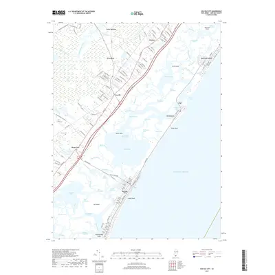
2019 Map of Sea Isle City
USGS Topo · Published 2019About this map
Sea Isle City and the barrier island communities of Cape May County are defined by an intricate network of tidal channels and salt marshes. The landscape is split between developed coastal strips like Ludlam Beach and the inland reaches of the Great Cedar Swamp. Along the coast, the Intracoastal Waterway threads through Ludlam Bay and Strathmere Bay, connecting the inlets that punctuate the shoreline. A Bascule Bridge provides a critical link to Strathmere, illustrating the engineering required to navigate this shifting amphibious environment. Further inland, older settlements like Seaville and Ocean View sit on higher ground, while Woodland Cem and Magnolia Lake mark the transition toward the swampy interior. This modern survey shows the established street grids of Ocean City and the southern tip of the quadrangle at Townsends Inlet, recording the density of mid-Atlantic coastal habitation adjacent to preserved wetlands like Sedge Island and Gull Island.
Find a feature on this map
140 named features on this map. Tap any name to fly to it.
Don’t see what you’re looking for? This feature index may not catch every label — zoom into the map to look around manually.
Map Details
Editions of this 2019 Sea Isle City Map
This is the sole edition of this map. No revisions or reprints were ever made.
Other maps of this area

1884 · Sea Isle
USGS Topo · 1:62,500

1888 · Dennisville
USGS Topo · 1:62,500

1888 · Sea Isle
USGS Topo · 1:62,500

1890 · Great Egg Harbor
USGS Topo · 1:62,500

1890 · Tuckahoe
USGS Topo · 1:62,500

1893 · Great Egg Harbor
USGS Topo · 1:62,500

1893 · Tuckahoe
USGS Topo · 1:62,500

1894 · Dennisville
USGS Topo · 1:62,500

1894 · Sea Isle
USGS Topo · 1:62,500

1918 · Great Egg Harbor
USGS Topo · 1:62,500