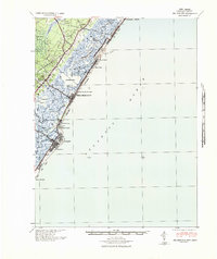
1941 Map of Sea Isle City
USGS Topo · Published 1941About this map
The Pennsylvania-Reading Seashore Lines cuts a direct path across the marshes and sounds of Cape May County, connecting the mainland to the barrier islands before the mid-century surge of coastal development. This military tactical map, prepared by the Corps of Engineers, reveals a landscape defined by the intricate waterways of Ludlam Bay and Townsend Sound. On the barrier beaches, the settlements of Sea Isle City, Avalon, and Stone Harbor are shown with their early street grids and rail connections, including the Ludlam Beach Light standing as a sentinel on the shore. Inland, the dense Great Cedar Swamp and small villages like Seaville and Palermo provide a stark contrast to the shifting sands of Whale Beach and Seven Mile Beach. The presence of the Toll Bridge at Townsends Inlet highlights the emerging road network that would eventually reshape this shoreline.
Find a feature on this map
35 named features on this map. Tap any name to fly to it.
Don’t see what you’re looking for? This feature index may not catch every label — zoom into the map to look around manually.
Map Details
Editions of this 1941 Sea Isle City Map
This is the sole edition of this map. No revisions or reprints were ever made.
Other maps of this area

1884 · Sea Isle
USGS Topo · 1:62,500

1887 · Atlantic City
USGS Topo · 1:62,500

1888 · Cape May
USGS Topo · 1:62,500

1888 · Dennisville
USGS Topo · 1:62,500

1888 · Sea Isle
USGS Topo · 1:62,500

1890 · Great Egg Harbor
USGS Topo · 1:62,500

1890 · Tuckahoe
USGS Topo · 1:62,500

1893 · Cape May
USGS Topo · 1:62,500

1893 · Great Egg Harbor
USGS Topo · 1:62,500

1893 · Tuckahoe
USGS Topo · 1:62,500