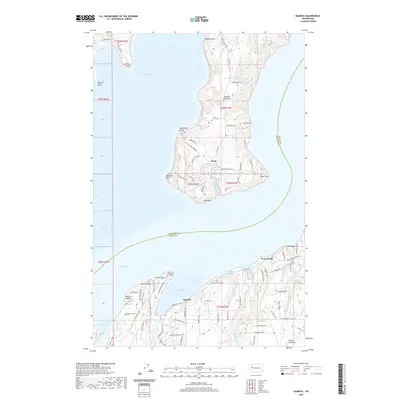
2020 Map of Seabeck
USGS Topo · Published 2020About this map
The Toandos Peninsula and the Great Peninsula face one another across the waters of the Hood Canal in this topographic study. The settlement of Seabeck serves as a central point along the Kitsap County shoreline, flanked by coastal communities such as Miami Beach and Maple Beach. To the north, across Seabeck Bay, the southern tip of the Toandos Peninsula is home to the community of Coyle, where the landscape is defined by its maritime proximity to Fisherman Harbor and the expansive Dabob Bay. The map captures the intricate shoreline of this region, including Little Beef Harbor and Big Beef Harbor, which are fed by their respective creeks. Inland, the area near Warrenville and Lone Rock shows a transition from the water-oriented life of the coast to the upland terrain of the peninsula, marked by a network of local roads like Seabeck Hwy NW and Wade Rd NW.
Find a feature on this map
93 named features on this map. Tap any name to fly to it.
Don’t see what you’re looking for? This feature index may not catch every label — zoom into the map to look around manually.
Map Details
Editions of this 2020 Seabeck Map
This is the sole edition of this map. No revisions or reprints were ever made.
Other maps of this area

1936 · Point Misery
USGS Topo · 1:62,500

1937 · Port Orchard
USGS Topo · 1:62,500

1937 · Port Gamble
USGS Topo · 1:62,500

1940 · Port Gamble
USGS Topo · 1:62,500

1940 · Point Misery
USGS Topo · 1:62,500

1940 · Quilcene
USGS Topo · 1:62,500

1953 · Seabeck
USGS Topo · 1:24,000

1953 · Poulsbo
USGS Topo · 1:24,000

1953 · Quilcene
USGS Topo · 1:24,000

1953 · Mt. Walker
USGS Topo · 1:24,000