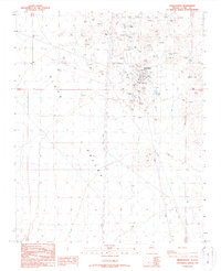
1989 Map of Searchlight
USGS Topo · Published 1990About this map
Searchlight serves as the hub for this high-desert mining district, situated above the broad expanse of Piute Valley. The town's grid is surrounded by a dense concentration of mineral claims and shafts, reflecting a legacy of gold and silver extraction that continued to shape the landscape into the late 20th century. Notable operations like the Quartette Mine, Pompeii Mine, and Blossom Mine cluster tightly around the settlement, while the Cem and Searchlight Airport mark the community's outskirts. The presence of numerous prospects, adits, and tailings piles across the terrain indicates the extensive subterranean exploration that defines this region of Clark County. Beyond the town center, infrastructure like the Trans Lines and Pipeline cut through the desert, supporting the industrial activity of the era.
Find a feature on this map
40 named features on this map. Tap any name to fly to it.
Don’t see what you’re looking for? This feature index may not catch every label — zoom into the map to look around manually.
Map Details
Editions of this 1989 Searchlight Map
This is the sole edition of this map. No revisions or reprints were ever made.
Other maps of this area

1886 · Camp Mohave
USGS Topo · 1:250,000

1892 · Camp Mohave
USGS Topo · 1:250,000

1910 · Ivanpah
USGS Topo · 1:250,000

1912 · Ivanpah
USGS Topo · 1:250,000

1926 · Nelson
USGS Topo · 1:96,000

1926 · Mohave City
USGS Topo · 1:96,000

1942 · Camp Mohave
USGS Topo · 1:250,000

1942 · Ivanpah
USGS Topo · 1:250,000

1947 · Kingman
USGS Topo · 1:250,000

1948 · Kingman
USGS Topo · 1:250,000