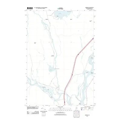
2011 Map of Seboeis
USGS Topo · Published 2011About this map
Seboeis and Gilford anchor this North Woods landscape where the Penobscot River meets the Piscataquis River. The topography is defined by glacial features and water management, notably the Pond Farm Pond Dam and the West Enfield Dam at the southern edge. The map highlights the intricate river system including Merrill Brook, Gordon Brook, and Tate Brook, which drain into the main channels around islands like Lowell Island, Doe Island, and Big Island. This 2011 survey captures the area’s transition from high ridges such as Carpenter Ridge and Randall Ridge to the low-lying wetlands of Sweat Bog Brook. Notable for local researchers is the Hoytville Horseback, a distinct glacial ridge running parallel to Seboeis Stream, and the network of logging and local roads like Maine Rd and Railroad Pit Rd that serve this timber-rich region of Penobscot County.
Find a feature on this map
43 named features on this map. Tap any name to fly to it.
Don’t see what you’re looking for? This feature index may not catch every label — zoom into the map to look around manually.
Map Details
Editions of this 2011 Seboeis Map
This is the sole edition of this map. No revisions or reprints were ever made.
Other maps of this area

1917 · Passadumkeag
USGS Topo · 1:62,500

1933 · Boyd Lake
USGS Topo · 1:62,500

1942 · Lincoln
USGS Topo · 1:62,500

1947 · Schoodic
USGS Topo · 1:62,500

1949 · Schoodic
USGS Topo · 1:62,500

1951 · Boyd Lake
USGS Topo · 1:50,000

1954 · Millinocket
USGS Topo · 1:250,000

1955 · Boyd Lake
USGS Topo · 1:62,500

1957 · Lincoln
USGS Topo · 1:62,500

1958 · Millinocket
USGS Topo · 1:250,000