1970 Map of Sedan SE
USGS Topo · Published 1973About this map
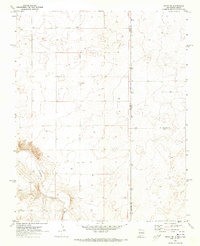
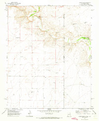
Shaha Cem stands as a solitary genealogical landmark in this high plains landscape during the transition from the late 1960s into 1970. The terrain is defined by a sparse ranching economy where water is the primary driver of settlement and land use, evidenced by the numerous marked Well sites and a single Corral situated near the jurisdictional corner of Union and Dallam counties. The deep incision of Tramperos Creek cuts through the southwestern corner, offering a stark contrast to the surrounding plateau. This survey effectively documents the intersection of three distinct county lines and the interstate boundary of New Mexico and Texas, providing a precise record of property and political divisions in a region where physical landmarks are few.
Find a feature on this map
8 named features on this map. Tap any name to fly to it.
Don’t see what you’re looking for? This feature index may not catch every label — zoom into the map to look around manually.
Map Details
Editions of this 1970 Sedan SE Map
This is the sole edition of this map. No revisions or reprints were ever made.
Other maps of this area

1954 · Tucumcari
USGS Topo · 1:250,000

1954 · Dalhart
USGS Topo · 1:250,000

1958 · Tucumcari
USGS Topo · 1:250,000

1958 · Dalhart
USGS Topo · 1:250,000

1962 · Dalhart
USGS Topo · 1:250,000
1970 · Stead
USGS Topo · 1:24,000
1970 · Sedan
USGS Topo · 1:24,000
1970 · Sedan NE
USGS Topo · 1:24,000
1971 · Koger Ranch
USGS Topo · 1:24,000
1971 · Beck Ranch
USGS Topo · 1:24,000