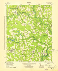
1945 Map of Sedley
USGS Topo · Published 1945About this map
Sedley and the surrounding Tidewater landscape appear in this 1940s survey by the U. S. Coast and Geodetic Survey for the War Department. The map details a rural network of swampy lowlands and agricultural settlements, where the Virginian railway and the Blackwater River shaped local transport and commerce. Significant cultural sites for genealogists include several integrated institutions like the Ebenezer Ch and Sch and the Rosenwald Sch, reflecting the era's social infrastructure. The terrain is defined by extensive wetlands including Seacock Swamp and Round Hill Swamp, alongside vital water resources such as Whitefields Millpond and Johnson Millpond. Small communities and junctions such as Pulleys Crossroads, Berlin, and Burdette are recorded at a mid-century scale, showing the transition from traditional millponds to modern infrastructure like the power line and underground water pipeline cutting across the Jerusalem district.
Find a feature on this map
39 named features on this map. Tap any name to fly to it.
Don’t see what you’re looking for? This feature index may not catch every label — zoom into the map to look around manually.
Map Details
Editions of this 1945 Sedley Map
This is the sole edition of this map. No revisions or reprints were ever made.
Other maps of this area

1919 · Homeville
USGS Topo · 1:48,000

1919 · Boykins
USGS Topo · 1:48,000

1920 · Holland
USGS Topo · 1:62,500

1920 · Ivor
USGS Topo · 1:62,500

1920 · Homeville
USGS Topo · 1:62,500

1920 · Boykins
USGS Topo · 1:62,500

1943 · Holland
USGS Topo · 1:62,500

1943 · Manry
USGS Topo · 1:31,680

1943 · Vicksville
USGS Topo · 1:31,680

1944 · Ivor
USGS Topo · 1:24,000