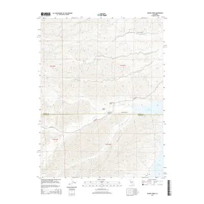
2015 Map of Sehorn Creek
USGS Topo · Published 2015About this map
The Sacramento Valley and Central Valley floor meet the rising western foothills in this survey of the boundary between Tehama Co and Glenn Co. The landscape is defined by a dense network of seasonal drainages, including Sehorn Creek, Elmore Creek, and N Fork Stony Cr, which carve through the terrain before reaching the waters of Black Butte Lake. For local historians and genealogists, the Elmore Cemetery situated near Long Hollow serves as a significant landmark of the area's early settlement. Local transit is captured via Co Road 200 and Morrison Bryan Rd, which navigate the contours of Masterson Hollow and the surrounding rangeland. The map illustrates the transition from flat valley agriculture to the broken topographic ridges typical of this part of Northern California.
Find a feature on this map
25 named features on this map. Tap any name to fly to it.
Don’t see what you’re looking for? This feature index may not catch every label — zoom into the map to look around manually.
Map Details
Editions of this 2015 Sehorn Creek Map
This is the sole edition of this map. No revisions or reprints were ever made.
Other maps of this area

1904 · Walker Creek
USGS Topo · 1:31,680

1919 · Fruto
USGS Topo · 1:62,500

1919 · Elk Creek
USGS Topo · 1:62,500

1944 · Fruto
USGS Topo · 1:62,500

1944 · Flournoy
USGS Topo · 1:62,500

1948 · Elk Creek
USGS Topo · 1:62,500
1952 · Fruto NE
USGS Topo · 1:24,000

1952 · Paskenta
USGS Topo · 1:62,500

1957 · Elk Creek
USGS Topo · 1:62,500

1957 · Ukiah
USGS Topo · 1:250,000