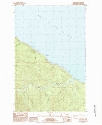
1984 Map of Sekiu River
USGS Topo · Published 1984About this map
The Strait of Juan de Fuca defines the northern edge of this Olympic Peninsula landscape, where the coastline is marked by rocky outcroppings and the distinctive Shipwreck Point. In the mid-1980s, the area's timber and aviation history is visible through a network of roads including the Main Line Road, various private tracks, and a Landing Strip (Abandoned) situated on the eastern side of the sheet. The drainage system is dominated by the Sekiu River and its South Fork, which are fed by numerous named tributaries such as Carpenters Creek and Rasmussen Creek. Topography is steep and densely wooded, indicated by the winding paths of 4wd trails and the placement of a Radio Facility and a Powerline corridor that cut through the high ground above the coast.
Find a feature on this map
23 named features on this map. Tap any name to fly to it.
Don’t see what you’re looking for? This feature index may not catch every label — zoom into the map to look around manually.
Map Details
Editions of this 1984 Sekiu River Map
This is the sole edition of this map. No revisions or reprints were ever made.
Other maps of this area

1935 · Clallam
USGS Topo · 1:62,500

1935 · Ozette Lake
USGS Topo · 1:62,500

1935 · Lake Pleasant
USGS Topo · 1:62,500

1938 · Cape Flattery
USGS Topo · 1:62,500

1942 · Clallam
USGS Topo · 1:62,500

1942 · Ozette Lake
USGS Topo · 1:62,500

1942 · Lake Pleasant
USGS Topo · 1:62,500

1953 · Cape Flattery
USGS Topo · 1:250,000

1956 · Ozette Lake
USGS Topo · 1:62,500

1957 · Lake Pleasant
USGS Topo · 1:62,500