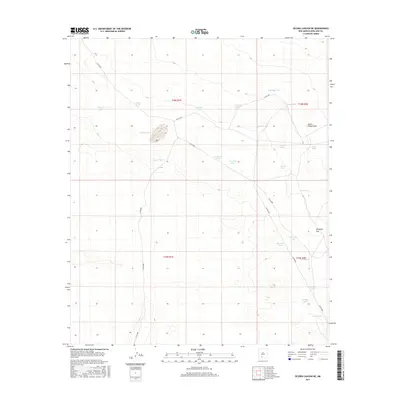
2017 Map of Selden Canyon NE
USGS Topo · Published 2017About this map
Horse Camp Draw and the broad expanse of Antelope Flat dominate this arid landscape in Doña Ana County. This 2017 survey reflects a remote environment defined by its water management, where a dense network of catchment basins like Pierce Tank, Cassady Tank, and Valentine Tank provide essential resources for cattle ranching. The terrain is marked by township and range divisions, specifically t18s r1e and t19s r2e, showing how the land was partitioned for use. Local transport is limited to a few designated routes, such as Co RD e077 and Co RD e088, which navigate between the numerous named tanks. The distribution of these features, including Rawhide Tank and Tobosa Tank, illustrates the persistent reliance on surface water collection in this part of New Mexico.
Find a feature on this map
31 named features on this map. Tap any name to fly to it.
Don’t see what you’re looking for? This feature index may not catch every label — zoom into the map to look around manually.
Map Details
Editions of this 2017 Selden Canyon NE Map
This is the sole edition of this map. No revisions or reprints were ever made.
Other maps of this area

1916 · Tonuco
USGS Topo · 1:125,000

1932 · Tonuco
USGS Topo · 1:125,000

1948 · Chicken Well
USGS Topo · 1:62,500

1948 · Bear Peak
USGS Topo · 1:62,500

1948 · San Diego Mountain
USGS Topo · 1:62,500

1948 · Kaylor Mountain
USGS Topo · 1:62,500

1955 · Las Cruces
USGS Topo · 1:250,000

1958 · Las Cruces
USGS Topo · 1:250,000

1981 · Gilmore Draw
USGS Topo · 1:24,000
1981 · Fleck Draw
USGS Topo · 1:24,000