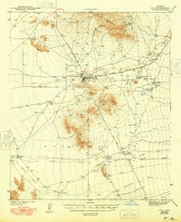
1941 Map of Sells
USGS Topo · Published 1969About this map
The Papago Indian Reservation dominates this 1941 landscape, centered on the tribal headquarters at Sells. At this time, the desert floor is a network of washes and scattered O'odham settlements, with Topawa serving as a significant southern hub. The presence of the San Solano Mission and the Topawa P O highlights the village's role as a communal and spiritual center. To the north, industrial activity is etched into the South Comobabi Mts where the Green Mine, Midnite Mine, and Jaeger Mine represent the region's mining legacy. The terrain is defined by the prominent Artesa Mountains and wide desert plains drained by the Sells Wash and Fresnal Wash. Smaller habitations such as Ali Molina and Chiawuli Tak are connected by the Ajo-Tucson Highway, showing the early 20th-century transportation routes through the Sonoran Desert.
Find a feature on this map
30 named features on this map. Tap any name to fly to it.
Don’t see what you’re looking for? This feature index may not catch every label — zoom into the map to look around manually.
Map Details
Editions of this 1941 Sells Map
This is the sole edition of this map. No revisions or reprints were ever made.