
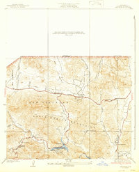
1932 Map of Seminole
USGS Topo · Published 1932About this map
The Santa Monica Mountains and the canyon-cut landscapes of Las Virgenes define this 1932 survey, which documents the early road networks and rural outposts of western Los Angeles County. Before the suburban expansion of the later 20th century, the region was characterized by small clusters such as Malibu Junction, Picture City, and the Agoura PO. The southern portion of the map highlights the recreational development around Malibu Lake, including the Malibu Lake Country Club, showing how this portion of the interior range was transitioning into a retreat for the region's growing population.
Find a feature on this map
28 named features on this map. Tap any name to fly to it.
Don’t see what you’re looking for? This feature index may not catch every label — zoom into the map to look around manually.
Map Details
Editions of this 1932 Seminole Map
2 editions found
Other maps of this area

1900 · Triunfo Pass
USGS Topo · 1:62,500

1903 · Calabasas
USGS Topo · 1:62,500

1903 · Camulos
USGS Topo · 1:125,000

1921 · Triunfo Pass
USGS Topo · 1:62,500

1925 · Chatsworth
USGS Topo · 1:24,000

1927 · Chatsworth
USGS Topo · 1:24,000

1928 · Dry Canyon
USGS Topo · 1:24,000
1929 · Chatsworth
USGS Topo · 1:24,000

1929 · Dume Point
USGS Topo · 1:24,000
1929 · Dry Canyon
USGS Topo · 1:24,000