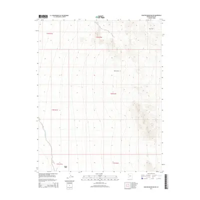
2014 Map of Senator Mountain SW
USGS Topo · Published 2014About this map
White Hills dominates the topography in this high-desert region of Mohave County, where the landscape transitions into the open expanse of the Mojave Desert. The map reveals a land defined by arid drainage patterns, most notably Detrital Wash, which cuts through the western section of the terrain. This 2014 survey documents the remote character of the area, showing the relationship between the rising elevations of the mountain ranges and the dry alluvial plains below. The presence of the White Hills settlement in the north suggests the sparse but persistent human footprint in a region historically shaped by mining and ranching interests within the vast public lands of the Arizona desert.
Find a feature on this map
10 named features on this map. Tap any name to fly to it.
Don’t see what you’re looking for? This feature index may not catch every label — zoom into the map to look around manually.
Map Details
Editions of this 2014 Senator Mountain SW Map
This is the sole edition of this map. No revisions or reprints were ever made.
Other maps of this area

1886 · Camp Mohave
USGS Topo · 1:250,000

1892 · Camp Mohave
USGS Topo · 1:250,000

1926 · Nelson
USGS Topo · 1:96,000

1942 · Camp Mohave
USGS Topo · 1:250,000

1947 · Kingman
USGS Topo · 1:250,000

1948 · Kingman
USGS Topo · 1:250,000

1954 · Kingman
USGS Topo · 1:250,000

1955 · Kingman
USGS Topo · 1:250,000

1958 · Kingman
USGS Topo · 1:250,000
1959 · Mt. Perkins
USGS Topo · 1:62,500