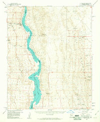
1959 Map of Mt. Perkins
USGS Topo · Published 1960About this map
Colorado River waters, filling the canyons as part of the Lake Mead National Recreation Area, define the border between Arizona and Nevada in this late 1950s survey. On the Nevada side, the landscape is marked by small settlements and landings such as Nelsons Landing and Capital Camp, which served as entry points to the steep desert terrain. The eastern Arizona portion is dominated by the Black Mountains, where a significant mining history is visible through a high concentration of claims. Hard rock mining sites like the Gold Bug Mine, Mohave Mine, and Dixie Queen Mine pepper the slopes of Mt Perkins and Mt Davis. The map traces numerous jeep trails through Detrital Valley and Cottonwood Valley, providing a record of the primitive road network used by prospectors and recreationists before modern development reshaped access to these remote desert ranges.
Find a feature on this map
40 named features on this map. Tap any name to fly to it.
Don’t see what you’re looking for? This feature index may not catch every label — zoom into the map to look around manually.
Map Details
Editions of this 1959 Mt. Perkins Map
4 editions found
Other maps of this area

1886 · Camp Mohave
USGS Topo · 1:250,000

1892 · Camp Mohave
USGS Topo · 1:250,000

1926 · Nelson
USGS Topo · 1:96,000

1926 · Mohave City
USGS Topo · 1:96,000

1942 · Camp Mohave
USGS Topo · 1:250,000

1947 · Kingman
USGS Topo · 1:250,000

1948 · Kingman
USGS Topo · 1:250,000

1954 · Kingman
USGS Topo · 1:250,000

1955 · Kingman
USGS Topo · 1:250,000

1958 · Kingman
USGS Topo · 1:250,000