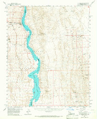
1959 Map of Mt. Perkins
USGS Topo · Published 1967About this map
Black Mountains dominate the eastern half of this landscape, where a concentrated network of mining operations reveals the region's industrial heritage during the mid-20th century. Claims such as the Mohave Mine, Gold Bug Mine, and Mockingbird Mine are interspersed with tunnels and jeep trails, marking a high-desert economy built on extraction. To the west, the Colorado River flows through the Lake Mead National Recreation Area, serving as the border between Clark and Mohave counties.
Find a feature on this map
38 named features on this map. Tap any name to fly to it.
Don’t see what you’re looking for? This feature index may not catch every label — zoom into the map to look around manually.
Map Details
Editions of this 1959 Mt. Perkins Map
4 editions found
Other maps of this area

1886 · Camp Mohave
USGS Topo · 1:250,000

1892 · Camp Mohave
USGS Topo · 1:250,000

1926 · Nelson
USGS Topo · 1:96,000

1926 · Mohave City
USGS Topo · 1:96,000

1942 · Camp Mohave
USGS Topo · 1:250,000

1947 · Kingman
USGS Topo · 1:250,000

1948 · Kingman
USGS Topo · 1:250,000

1954 · Kingman
USGS Topo · 1:250,000

1955 · Kingman
USGS Topo · 1:250,000

1958 · Kingman
USGS Topo · 1:250,000