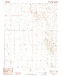
1989 Map of Senator Mountain SW
USGS Topo · Published 1990About this map
Detrital Valley dominates this arid landscape in Mohave County, where the desert floor meets the rising terrain of the White Hills to the east. This 1989 provisional survey captures a remote region shaped by geological exploration and basic infrastructure, where Detrital Wash meanders through the western flats. Mining activity is evident throughout the eastern slopes, with several prospects, a prospect site, and mine shafts tucked into the hillsides. These features, along with a solitary Corral and scattered gravel pits, suggest a landscape defined by small-scale extraction and open-range livestock management. A network of 4wd tracks and a prominent trans line provide the only significant markers of modern presence across this vast stretch of Arizona desert, serving as a reliable record of the area's physical state just before the turn of the century.
Find a feature on this map
14 named features on this map. Tap any name to fly to it.
Don’t see what you’re looking for? This feature index may not catch every label — zoom into the map to look around manually.
Map Details
Editions of this 1989 Senator Mountain SW Map
This is the sole edition of this map. No revisions or reprints were ever made.
Other maps of this area

1886 · Camp Mohave
USGS Topo · 1:250,000

1892 · Camp Mohave
USGS Topo · 1:250,000

1926 · Nelson
USGS Topo · 1:96,000

1942 · Camp Mohave
USGS Topo · 1:250,000

1947 · Kingman
USGS Topo · 1:250,000

1948 · Kingman
USGS Topo · 1:250,000

1954 · Kingman
USGS Topo · 1:250,000

1955 · Kingman
USGS Topo · 1:250,000

1958 · Kingman
USGS Topo · 1:250,000
1959 · Mt. Perkins
USGS Topo · 1:62,500