1944 Map of Seneca
USGS Topo · Published 1963About this map
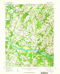
The Potomac River corridor and its historic transportation infrastructure anchor this mid-century survey of the Maryland-Virginia border. The Chesapeake and Ohio Canal parallels the river, featuring the notable Monocacy Aqueduct at the confluence with the Monocacy River. To the east, the Baltimore and Ohio RR serves established rail towns like Boyds, Germantown, and Barnesville, where Barnesville Sta and the Sellman Sch served the local rural community.
Find a feature on this map
95 named features on this map. Tap any name to fly to it.
Don’t see what you’re looking for? This feature index may not catch every label — zoom into the map to look around manually.
Map Details
Editions of this 1944 Seneca Map
This is the sole edition of this map. No revisions or reprints were ever made.
Other maps of this area

1884 · Harpers Ferry
USGS Topo · 1:125,000

1890 · Mt. Vernon
USGS Topo · 1:125,000

1891 · Harpers Ferry
USGS Topo · 1:125,000

1891 · Mt. Vernon
USGS Topo · 1:125,000

1893 · Frederick
USGS Topo · 1:125,000

1893 · Harpers Ferry
USGS Topo · 1:125,000

1894 · Warrenton
USGS Topo · 1:125,000

1894 · Frederick
USGS Topo · 1:125,000

1894 · Mt. Vernon
USGS Topo · 1:125,000

1897 · Mt. Vernon
USGS Topo · 1:125,000