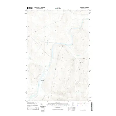
2014 Map of Seven Islands
USGS Topo · Published 2014About this map
Seven Islands emerges as a distinct cluster of riverine landforms along the Saint John River in this northern Maine landscape. The river, which serves as a primary geographical axis, is marked by the Priestly Rapids to the northeast and is fed by several significant drainage systems, including Lizotte Brook, White Brook, and Cunliffe Brook. The terrain is defined by its isolation and the network of logging and access roads that crisscross the timberlands, such as Maibec Rd and Estcourt Rd.
Find a feature on this map
14 named features on this map. Tap any name to fly to it.
Don’t see what you’re looking for? This feature index may not catch every label — zoom into the map to look around manually.
Map Details
Editions of this 2014 Seven Islands Map
This is the sole edition of this map. No revisions or reprints were ever made.
Other maps of this area

1932 · Umsaskis Lake
USGS Topo · 1:48,000

1935 · Umsaskis Lake
USGS Topo · 1:62,500

1954 · Presque Isle
USGS Topo · 1:250,000

1955 · Round Pond
USGS Topo · 1:62,500

1955 · Clayton Lake
USGS Topo · 1:62,500

1955 · Seven Islands
USGS Topo · 1:62,500

1958 · Presque Isle
USGS Topo · 1:250,000

1960 · Presque Isle
USGS Topo · 1:250,000

1976 · Seven Islands
USGS Topo · 1:24,000
1976 · Ninemile Deadwater
USGS Topo · 1:24,000