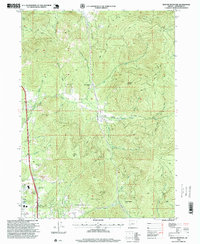
1996 Map of Sexton Mountain
USGS Topo · Published 1999About this map
Mining operations and remote timber sites define this pocket of the Southern Oregon landscape during the mid-1990s. The region is marked by historic resource extraction, with numerous workings such as the Lucky Queen Mine and Hammersly Mine dotting the drainages of Jumpoff Joe Creek and Louse Creek. While Winona serves as a small localized center, the map also identifies the former locations of Lucky Queen (Site) and Forest Queen (Site), highlighting the ephemeral nature of mountain camps in this rugged area. High peaks like Sexton Mtn and Walker Mountain loom over a network of 4WD trails and forest roads that connect deeper prospects like the Twelve O'clock Mine and Orofino Mine. Traces of community life appear in the south at Sportsman Park and a surviving Schoolhouse label, providing a look at the interplay between industry and settlement in Josephine County.
Find a feature on this map
38 named features on this map. Tap any name to fly to it.
Don’t see what you’re looking for? This feature index may not catch every label — zoom into the map to look around manually.
Map Details
Editions of this 1996 Sexton Mountain Map
This is the sole edition of this map. No revisions or reprints were ever made.
Other maps of this area

1904 · Riddle
USGS Topo · 1:125,000

1908 · Grants Pass
USGS Topo · 1:125,000

1954 · Glendale
USGS Topo · 1:62,500

1954 · Gold Hill
USGS Topo · 1:62,500

1954 · Wimer
USGS Topo · 1:62,500

1954 · Grants Pass
USGS Topo · 1:62,500

1955 · Medford
USGS Topo · 1:250,000

1957 · Medford
USGS Topo · 1:250,000

1958 · Medford
USGS Topo · 1:250,000

1974 · Grants Pass NW
USGS Topo · 1:24,000