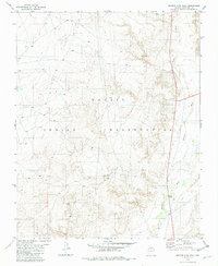
1982 Map of Shadow Mtn. Well
USGS Topo · Published 1982About this map
Shadow Mtn Well serves as a remote landmark within the extensive Navajo Indian Reservation in Coconino County. The landscape is defined by the drainage patterns of Hamblin Wash and Moenkopi Wash, which shape the arid terrain of northern Arizona. Human activity in this high-desert environment is evidenced by early industrial and resource-gathering sites, including several Prospects near the northern boundary and a Cinder Pit to the south. This 1982 survey, based on 1970s aerial photography, documents the intersection of modern transportation and essential water infrastructure. A Gaging Station located along the wash indicates the importance of monitoring water flow in this region, while the junction of Highway 89 and Highway 160 provides the primary transit corridor through the reservation lands.
Find a feature on this map
9 named features on this map. Tap any name to fly to it.
Don’t see what you’re looking for? This feature index may not catch every label — zoom into the map to look around manually.
Map Details
Editions of this 1982 Shadow Mtn. Well Map
This is the sole edition of this map. No revisions or reprints were ever made.
Other maps of this area

1886 · San Francisco Mtns
USGS Topo · 1:250,000

1886 · Echo Cliffs
USGS Topo · 1:250,000

1891 · San Francisco Mtns
USGS Topo · 1:250,000

1891 · Echo Cliffs
USGS Topo · 1:250,000

1894 · San Francisco Mtns
USGS Topo · 1:250,000

1899 · San Francisco Mtns
USGS Topo · 1:250,000

1947 · Flagstaff
USGS Topo · 1:250,000

1954 · Flagstaff
USGS Topo · 1:250,000

1955 · Coconino Pt NE
USGS Topo · 1:24,000

1955 · Blue Spring NE
USGS Topo · 1:24,000