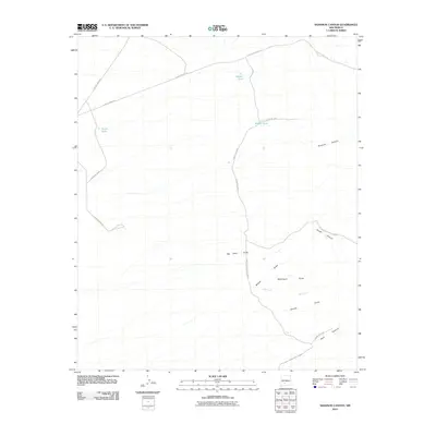
2010 Map of Shannon Canyon
USGS Topo · Published 2010About this map
The vast, arid expanse of the White Sands Missile Range occupies the southern and eastern portions of this quadrangle, defining the land use and accessibility of the region. This 2010 survey illustrates a landscape primarily shaped by intermittent drainage systems and essential water infrastructure necessary for range operations or ranching. Numerous named ephemeral channels, including Willow Draw, Waterhole Draw, and Big Ditch Draw, cut through the terrain toward the larger Shannon Canyon. Human presence is evidenced by a network of rural routes such as County Road A-28 and several strategically placed reservoirs like Hardin Tank, Middle Tank, and South Tank. The map also identifies local natural points of interest such as the Deer Lick and the isolated Well located within Well Canyon.
Find a feature on this map
21 named features on this map. Tap any name to fly to it.
Don’t see what you’re looking for? This feature index may not catch every label — zoom into the map to look around manually.
Map Details
Editions of this 2010 Shannon Canyon Map
This is the sole edition of this map. No revisions or reprints were ever made.
Other maps of this area

1916 · Salinas Peak
USGS Topo · 1:125,000

1948 · Sowell
USGS Topo · 1:62,500

1948 · Malpais Well
USGS Topo · 1:62,500

1948 · Black Top Mountain
USGS Topo · 1:62,500

1948 · Salinas Peak
USGS Topo · 1:62,500

1954 · Tularosa
USGS Topo · 1:250,000

1958 · Tularosa
USGS Topo · 1:250,000

1981 · Big Gyp Mountain
USGS Topo · 1:24,000
1981 · Shannon Canyon
USGS Topo · 1:24,000
1981 · Polecat Tank
USGS Topo · 1:24,000