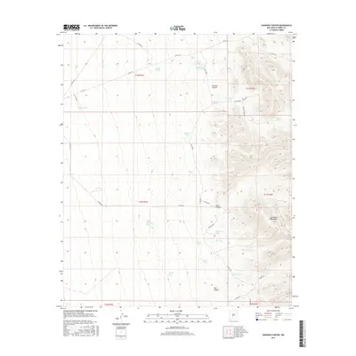
2017 Map of Shannon Canyon
USGS Topo · Published 2017About this map
The San Andres Mountains dominate the eastern reaches of this Sierra County landscape, where the rugged topography drops away into a complex system of arid drainage basins and livestock infrastructure. Water management is the primary human footprint visible on the terrain, evidenced by a dense network of catchment points such as Adobe House Tank, Hardin Tank, and the Shannon Tanks. These features, along with Shannon Well, suggest a long-standing reliance on carefully maintained water sources for ranching in this high-desert environment.
Find a feature on this map
41 named features on this map. Tap any name to fly to it.
Don’t see what you’re looking for? This feature index may not catch every label — zoom into the map to look around manually.
Map Details
Editions of this 2017 Shannon Canyon Map
This is the sole edition of this map. No revisions or reprints were ever made.
Other maps of this area

1916 · Salinas Peak
USGS Topo · 1:125,000

1948 · Sowell
USGS Topo · 1:62,500

1948 · Malpais Well
USGS Topo · 1:62,500

1948 · Black Top Mountain
USGS Topo · 1:62,500

1948 · Salinas Peak
USGS Topo · 1:62,500

1954 · Tularosa
USGS Topo · 1:250,000

1958 · Tularosa
USGS Topo · 1:250,000

1981 · Big Gyp Mountain
USGS Topo · 1:24,000
1981 · Shannon Canyon
USGS Topo · 1:24,000
1981 · Polecat Tank
USGS Topo · 1:24,000