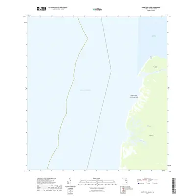
2021 Map of Shark River Island
USGS Topo · Published 2021About this map
Everglades National Park encompasses the entire terrestrial portion of this coastal survey, where the sawgrass and mangrove environments of The Everglades meet the tidal influence of the Gulf of Mexico. The landforms here are shaped by water, notably at Shark River Island and along the elevated ground of Shark River Bluff. This modern document records the intricate network of tidal channels that define the southwestern Florida shoreline, including the winding course of Big Sable Creek and the opening of Little Shark River into Ponce de Leon Bay. At the southern edge of the map, the prominent landmass of Cape Sable stands as a significant geographic marker. The absence of roads or permanent settlements underscores the wilderness character of this protected coastal landscape, providing a clear view of the hydrological patterns and coastal boundaries of the Monroe County coast in the early twenty-first century.
Find a feature on this map
9 named features on this map. Tap any name to fly to it.
Don’t see what you’re looking for? This feature index may not catch every label — zoom into the map to look around manually.
Map Details
Editions of this 2021 Shark River Island Map
This is the sole edition of this map. No revisions or reprints were ever made.
Other maps of this area

1956 · Miami
USGS Topo · 1:250,000

1958 · Miami
USGS Topo · 1:250,000

1972 · Whitewater Bay West
USGS Topo · 1:24,000

1972 · Harney River
USGS Topo · 1:24,000

1972 · Lake Ingraham East
USGS Topo · 1:24,000
1972 · Lake Ingraham West
USGS Topo · 1:24,000

1972 · Shark River Island
USGS Topo · 1:24,000

1972 · Shark Point
USGS Topo · 1:24,000

1981 · Cape Sable
USGS Topo · 1:100,000

1988 · Miami
USGS Topo · 1:250,000