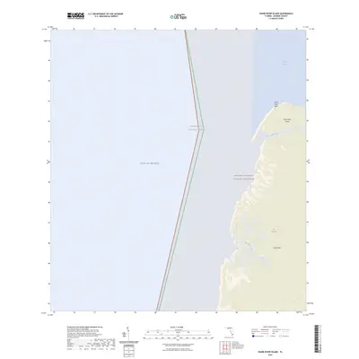
2024 Map of Shark River Island
USGS Topo · Published 2024About this map
Marjory Stoneman Douglas Wilderness dominates the eastern half of this coastal survey, where the terrestrial environment of south Florida meets the Gulf of Mexico. The map details the intricate, fragmented shoreline of The Everglades, characterized by a complex network of tidally influenced waterways including the Little Shark River and Big Sable Creek. These channels carve through the low-lying terrain, creating features such as Shark River Island and the elevated point at Shark River Bluff. To the south, the land mass broadens toward Cape Sable, while the western portion of the sheet is entirely open water, representing the coastal approach to Ponce de Leon Bay. This representation captures the preservation of one of the country's most significant wetlands within the Everglades National Park boundaries.
Find a feature on this map
10 named features on this map. Tap any name to fly to it.
Don’t see what you’re looking for? This feature index may not catch every label — zoom into the map to look around manually.
Map Details
Editions of this 2024 Shark River Island Map
This is the sole edition of this map. No revisions or reprints were ever made.
Other maps of this area

1956 · Miami
USGS Topo · 1:250,000

1958 · Miami
USGS Topo · 1:250,000

1972 · Whitewater Bay West
USGS Topo · 1:24,000

1972 · Harney River
USGS Topo · 1:24,000

1972 · Lake Ingraham East
USGS Topo · 1:24,000
1972 · Lake Ingraham West
USGS Topo · 1:24,000

1972 · Shark River Island
USGS Topo · 1:24,000

1972 · Shark Point
USGS Topo · 1:24,000

1981 · Cape Sable
USGS Topo · 1:100,000

1988 · Miami
USGS Topo · 1:250,000