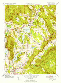
1948 Map of Sharon
USGS Topo · Published 1956About this map
Salisbury and Sharon anchor this 1948 survey of Litchfield County, showing a landscape defined by significant glacial lakes and prominent educational institutions. The area around Lakeville is centered on the large expanse of Wononskopomuc Lake, with The Hotchkiss School situated nearby. Further south, the map details the terrain around Wononpakook Lake and the smaller Silver Lake, alongside the facilities of Indian Mountain School.
Find a feature on this map
66 named features on this map. Tap any name to fly to it.
Don’t see what you’re looking for? This feature index may not catch every label — zoom into the map to look around manually.
Map Details
Editions of this 1948 Sharon Map
This is the sole edition of this map. No revisions or reprints were ever made.
Other maps of this area

1885 · Sheffield
USGS Topo · 1:62,500

1888 · Sheffield
USGS Topo · 1:62,500

1891 · Sheffield
USGS Topo · 1:62,500

1892 · Cornwall
USGS Topo · 1:62,500

1893 · Sheffield
USGS Topo · 1:62,500

1893 · Cornwall
USGS Topo · 1:62,500

1897 · Sheffield
USGS Topo · 1:62,500

1899 · Housatonic
USGS Topo · 1:125,000

1899 · Millbrook
USGS Topo · 1:62,500

1900 · Housatonic
USGS Topo · 1:125,000