
Loading...
Loading map...2023 Map of Sharon Springs
USGS Topo · Published 2023About this map
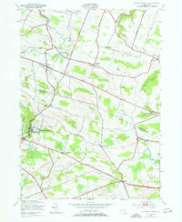
The village of Sharon Springs serves as a focal point for this landscape where the boundaries of Montgomery and Schoharie counties meet. This rural corridor is defined by its numerous family-named burial grounds and small agricultural settlements like Argusville, Mapletown, and Ames. The terrain is shaped by the winding paths of Canajoharie Creek and Brimstone Creek, alongside notable wetlands such as Cedar Swamp and Bear Swamp.
Find a feature on this map
99 named features on this map. Tap any name to fly to it.
Don’t see what you’re looking for? This feature index may not catch every label — zoom into the map to look around manually.
Map Details
Date Portrayed2023
Date Published2023
PublisherU.S. Geological Survey
Map TypeTopographic
Scale1:24000
Physical Dimensions24 x 29 inches
Editions of this 2023 Sharon Springs Map
This is the sole edition of this map. No revisions or reprints were ever made.
Historical Maps of Argusville Through Time
Featured Locations
Source Details
SourceU.S. Geological Survey
CopyrightPublic Domain