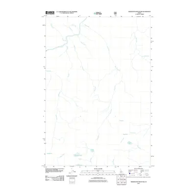
2011 Map of Sheepeater Mountain
USGS Topo · Published 2011About this map
The Salmon River cuts through this high-elevation Idaho landscape, serving as the primary drainage for a network of alpine creeks and lakes. The area is defined by its numerous small basins containing Sheepeater Lake, Lemhi Lake, and Cutthroat Lake, which feed the headwaters of south-flowing streams. The complex hydrology includes several distinctive water bodies like Frog Lake, Fish Lake, and Flossie Lake, alongside the appropriately named Frog Pond.
Find a feature on this map
22 named features on this map. Tap any name to fly to it.
Don’t see what you’re looking for? This feature index may not catch every label — zoom into the map to look around manually.
Map Details
Editions of this 2011 Sheepeater Mountain Map
This is the sole edition of this map. No revisions or reprints were ever made.
Other maps of this area

1956 · Elk City
USGS Topo · 1:250,000

1960 · Elk City
USGS Topo · 1:250,000

1974 · Meadow Of Doubt
USGS Topo · 1:24,000

1978 · Mosquito Peak
USGS Topo · 1:24,000

1978 · Chicken Peak
USGS Topo · 1:24,000

1978 · Hida Point
USGS Topo · 1:24,000
1978 · Lodgepole Creek
USGS Topo · 1:24,000

1979 · Dixie
USGS Topo · 1:24,000

1979 · Fivemile Bar
USGS Topo · 1:24,000
1979 · Whitewater Ranch
USGS Topo · 1:24,000