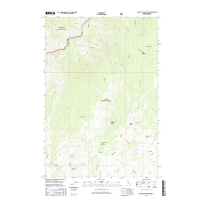
2017 Map of Sheepeater Mountain
USGS Topo · Published 2017About this map
Nez Perce National Forest and Payette National Forest meet in this remote Idaho County landscape, where the Salmon River cuts through the northern reaches of the quadrangle. The river’s path is marked by high-energy features like Growler Rapids and several small riverside flats including Widow Bar, Groundhog Bar, and Fall Creek Bar. This 2017 survey details a high-elevation backcountry network, following the historic Three Blaze route through a series of alpine meadows and summits. The drainage patterns of Trout Cr and Richardson Cr define the central terrain, leading toward the Chamberlain Basin. Notable high points such as Sheepeater Mountain and Burnt Knob overlook numerous small glacial lakes, including Sheepeater Lake, Fish Lake, and Flossie Lake, illustrating the post-glacial character of the Salmon River Mountains.
Find a feature on this map
53 named features on this map. Tap any name to fly to it.
Don’t see what you’re looking for? This feature index may not catch every label — zoom into the map to look around manually.
Map Details
Editions of this 2017 Sheepeater Mountain Map
This is the sole edition of this map. No revisions or reprints were ever made.
Other maps of this area

1956 · Elk City
USGS Topo · 1:250,000

1960 · Elk City
USGS Topo · 1:250,000

1974 · Meadow Of Doubt
USGS Topo · 1:24,000

1978 · Mosquito Peak
USGS Topo · 1:24,000

1978 · Chicken Peak
USGS Topo · 1:24,000

1978 · Hida Point
USGS Topo · 1:24,000
1978 · Lodgepole Creek
USGS Topo · 1:24,000

1979 · Dixie
USGS Topo · 1:24,000

1979 · Fivemile Bar
USGS Topo · 1:24,000
1979 · Whitewater Ranch
USGS Topo · 1:24,000