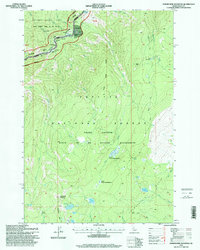
1995 Map of Sheepeater Mountain
USGS Topo · Published 1999About this map
The Salmon River cuts through the northern reaches of this Idaho landscape, designated here as a wild and scenic corridor where Campbells Ferry once provided a vital crossing. This remote area, split between the Payette National Forest and Nez Perce National Forest, contains evidence of early settlement and travel through the Frank Church River of No Return Wilderness. Significant human landmarks include the Jim Moore Place, a lone Grave, and the Shake Cabin (Site) near Richardson Creek. The map documents a rugged interior of high ridges and basins, such as the Chamberlain Basin, and traces historic routes like the Three Blaze Trail. Riparian areas like Lower Trout Creek Meadows and Upper Trout Creek Meadows stand out against the high-elevation peaks of Sheepeater Mountain and Red Top.
Find a feature on this map
47 named features on this map. Tap any name to fly to it.
Don’t see what you’re looking for? This feature index may not catch every label — zoom into the map to look around manually.
Map Details
Editions of this 1995 Sheepeater Mountain Map
This is the sole edition of this map. No revisions or reprints were ever made.
Other maps of this area

1956 · Elk City
USGS Topo · 1:250,000

1960 · Elk City
USGS Topo · 1:250,000

1974 · Meadow Of Doubt
USGS Topo · 1:24,000

1978 · Mosquito Peak
USGS Topo · 1:24,000

1978 · Chicken Peak
USGS Topo · 1:24,000

1978 · Hida Point
USGS Topo · 1:24,000
1978 · Lodgepole Creek
USGS Topo · 1:24,000

1979 · Dixie
USGS Topo · 1:24,000

1979 · Fivemile Bar
USGS Topo · 1:24,000
1979 · Whitewater Ranch
USGS Topo · 1:24,000