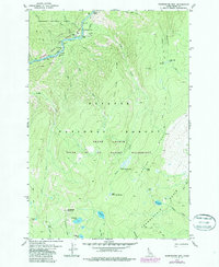
1979 Map of Sheepeater Mtn
USGS Topo · Published 1987About this map
Salmon River canyon life and backcountry isolation are documented here within the Frank Church River of No Return Wilderness. The map reveals the precarious footprint of human presence along the river, featuring the Jim Moore Place and Campbells Ferry, where a Campbells Ferry bridge and Landing Strip provided essential links to the outside world. Cultural markers like a Grave near the ferry and the Shake Cabin (Site) in Chamberlain Basin offer evidence of the area's early homesteading and resource history.
Find a feature on this map
52 named features on this map. Tap any name to fly to it.
Don’t see what you’re looking for? This feature index may not catch every label — zoom into the map to look around manually.
Map Details
Editions of this 1979 Sheepeater Mtn Map
This is the sole edition of this map. No revisions or reprints were ever made.
Other maps of this area

1956 · Elk City
USGS Topo · 1:250,000

1960 · Elk City
USGS Topo · 1:250,000

1974 · Meadow Of Doubt
USGS Topo · 1:24,000

1978 · Mosquito Peak
USGS Topo · 1:24,000

1978 · Chicken Peak
USGS Topo · 1:24,000

1978 · Hida Point
USGS Topo · 1:24,000
1978 · Lodgepole Creek
USGS Topo · 1:24,000

1979 · Dixie
USGS Topo · 1:24,000

1979 · Fivemile Bar
USGS Topo · 1:24,000
1979 · Whitewater Ranch
USGS Topo · 1:24,000