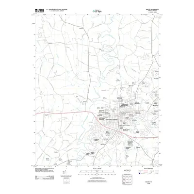
2010 Map of Shelby
USGS Topo · Published 2010About this map
The First Broad River meanders through Cleveland County, anchoring a landscape where the urban core of Shelby meets established rural communities like Kingstown, Metcalf, and Zion. This 2010 survey illustrates the city's significant residential expansion through numerous named developments such as Crestmont Heights, Kenmon Acres, and Valleyhall. The civic infrastructure is well-defined, with the Shelby Waterworks positioned along the river and the Shelby Municipal Airport serving the region's southern reaches. Genealogists will find several notable burial grounds, including Zion Cemetery and Sunset Cemetery. The surrounding terrain is dissected by numerous waterways like Brushy Creek and Hickory Creek, which have historically dictated the placement of early settlements and roads such as W Zion Church Rd and Old Boiling Springs Rd.
Find a feature on this map
128 named features on this map. Tap any name to fly to it.
Don’t see what you’re looking for? This feature index may not catch every label — zoom into the map to look around manually.
Map Details
Editions of this 2010 Shelby Map
This is the sole edition of this map. No revisions or reprints were ever made.
Other maps of this area

1906 · Kings Mountain
USGS Topo · 1:62,500

1908 · Kings Mountain
USGS Topo · 1:62,500

1909 · Gaffney
USGS Topo · 1:62,500

1909 · Lincolnton
USGS Topo · 1:62,500

1911 · Lincolnton
USGS Topo · 1:62,500

1950 · Shelby
USGS Topo · 1:62,500

1953 · Charlotte
USGS Topo · 1:250,000

1954 · Charlotte
USGS Topo · 1:250,000

1960 · Charlotte
USGS Topo · 1:250,000

1962 · Charlotte
USGS Topo · 1:250,000