
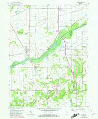
1959 Map of Shelby
USGS Topo · Published 1960About this map
The Kankakee River winds through the heart of this landscape, marking the historical boundaries between Lake, Newton, and Jasper counties. In the late 1950s, the area remained a complex network of managed waterways, with numerous engineered channels like the Singleton Ditch, Tully Ditch, and Brown Ditch evidence of long-term efforts to drain the marshy Kankakee basin for agricultural use. The Monon railroad serves as a primary north-south artery, connecting the settlements of Shelby, Thayer, and Roselawn. Small rural hubs such as Forest City and Knight appear alongside infrastructure like the Landing Strip near Thayer and various storage bins, reflecting the mid-century's agrarian and industrial character. Local landmarks, including a Sand and Gravel Pit and a riverside Gaging Sta, provide specific points of interest for those tracing the development of the river valley's economy.
Find a feature on this map
33 named features on this map. Tap any name to fly to it.
Don’t see what you’re looking for? This feature index may not catch every label — zoom into the map to look around manually.
Map Details
Editions of this 1959 Shelby Map
2 editions found
Other maps of this area

1953 · Leroy
USGS Topo · 1:24,000

1953 · Hebron
USGS Topo · 1:24,000

1953 · Lowell
USGS Topo · 1:24,000

1953 · Chicago
USGS Topo · 1:250,000

1957 · Chicago
USGS Topo · 1:250,000

1957 · DeMotte
USGS Topo · 1:24,000

1959 · Schneider
USGS Topo · 1:24,000

1962 · Parr
USGS Topo · 1:24,000
1962 · Fair Oaks
USGS Topo · 1:24,000
1962 · Enos
USGS Topo · 1:24,000