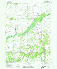
1959 Map of Shelby
USGS Topo · Published 1980About this map
The Kankakee River winds through this landscape, serving as a natural boundary between Lake, Newton, and Jasper counties. This 1959 planetable survey, updated with 1977 aerial revisions, reveals a territory defined by an intricate network of drainage systems, including the Otis-Boyle Ditch, Tully Ditch, and Singleton Ditch. These man-made channels reflect the historical efforts to reclaim the marshy wetlands of the Grand Kankakee Marsh for agricultural use. Settlements such as Shelby, Thayer, and Roselawn are linked by the Louisville and Nashville and Conrail railroads, which parallel the north-south corridors of travel. Notable local landmarks such as Lincoln Park and a small landing strip near Knight provide specific points of interest for genealogists and local historians tracing the development of these rural Indiana communities.
Find a feature on this map
38 named features on this map. Tap any name to fly to it.
Don’t see what you’re looking for? This feature index may not catch every label — zoom into the map to look around manually.
Map Details
Editions of this 1959 Shelby Map
2 editions found
Other maps of this area

1953 · Leroy
USGS Topo · 1:24,000

1953 · Hebron
USGS Topo · 1:24,000

1953 · Lowell
USGS Topo · 1:24,000

1953 · Chicago
USGS Topo · 1:250,000

1957 · Chicago
USGS Topo · 1:250,000

1957 · DeMotte
USGS Topo · 1:24,000

1959 · Schneider
USGS Topo · 1:24,000

1959 · Shelby
USGS Topo · 1:24,000

1962 · Parr
USGS Topo · 1:24,000
1962 · Fair Oaks
USGS Topo · 1:24,000