
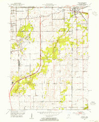
1953 Map of Lowell
USGS Topo · Published 1955About this map
Lowell serves as the focal point of this mid-century Indiana landscape, where the agricultural plains of the Kankakee Valley transition into the burgeoning lakeside communities of the north. The survey illustrates a region defined by its water and rail connections, specifically the northern resort influence at Cedar Lake and Dalecarlia, contrasted with the smaller, rail-oriented settlements like North Hayden and Belshaw.
Find a feature on this map
31 named features on this map. Tap any name to fly to it.
Don’t see what you’re looking for? This feature index may not catch every label — zoom into the map to look around manually.
Map Details
Editions of this 1953 Lowell Map
This is the sole edition of this map. No revisions or reprints were ever made.
Other maps of this area

1922 · Momence
USGS Topo · 1:62,500

1924 · Momence
USGS Topo · 1:62,500

1929 · Dyer
USGS Topo · 1:24,000

1930 · Dyer
USGS Topo · 1:24,000

1949 · Crete
USGS Topo · 1:62,500

1953 · Leroy
USGS Topo · 1:24,000

1953 · St. John
USGS Topo · 1:24,000

1953 · Crown Point
USGS Topo · 1:24,000

1953 · Beecher East
USGS Topo · 1:24,000
1953 · Dyer
USGS Topo · 1:24,000