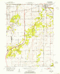
1953 Map of Dyer
USGS Topo · Published 1955About this map
Dyer and Chicago Heights anchor this mid-century survey of the Illinois-Indiana borderlands, capturing a region of rapid transition where suburban growth met established farmsteads. The landscape is defined by its complex transportation network, featuring the legendary Lincoln Highway and the Calumet Expressway cutting through the open fields of Crete and St John. Local history is preserved in the numerous country schools and churches, such as Klemme Sch and St Johns Ch, which served the rural communities of Brunswick and Kreitsburg. The map also illustrates the early leisure and industrial footprints of the area, from the Lincolnshire Country Club and Lincoln Fields to the Clay Pit and Gravel Pit operations that fueled local development.
Find a feature on this map
45 named features on this map. Tap any name to fly to it.
Don’t see what you’re looking for? This feature index may not catch every label — zoom into the map to look around manually.
Map Details
Editions of this 1953 Dyer Map
This is the sole edition of this map. No revisions or reprints were ever made.
Other maps of this area

1892 · Calumet
USGS Topo · 1:62,500

1893 · Calumet
USGS Topo · 1:62,500

1900 · Toleston
USGS Topo · 1:62,500

1900 · Calumet
USGS Topo · 1:62,500

1901 · Calumet
USGS Topo · 1:62,500

1929 · Calumet City
USGS Topo · 1:24,000

1929 · Harvey
USGS Topo · 1:24,000

1929 · Dyer
USGS Topo · 1:24,000

1930 · Dyer
USGS Topo · 1:24,000

1930 · Steger
USGS Topo · 1:24,000