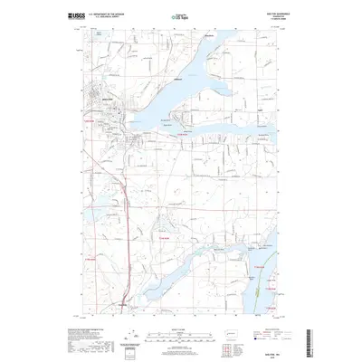
2020 Map of Shelton
USGS Topo · Published 2020About this map
Shelton serves as the focal point for this Mason County landscape, situated where Goldsborough Cr and Shelton Cr meet the head of Oakland Bay. The map illustrates a dense grid of streets including W Railroad Ave and W Cota St, reflecting the town's historical foundations in the timber and maritime industries. Surrounding the urban center, the terrain is defined by the intricate finger-like inlets of the southern Puget Sound, with Hammersley Inlet, Little Skookum Inlet, and Totten Inlet carving deep into the land. Smaller settlements and named locales like Johns Prairie, Oakland, and Bayshore dot the northern reaches, while Kamilche sits to the south. Local heritage is preserved in sites like the Miller Cem and landmarks such as Church Point and Kamilche Point, while numerous coves like Chapman Cove and Deer Harbor highlight the area's complex relationship with the tide and shore.
Find a feature on this map
89 named features on this map. Tap any name to fly to it.
Don’t see what you’re looking for? This feature index may not catch every label — zoom into the map to look around manually.
Map Details
Editions of this 2020 Shelton Map
This is the sole edition of this map. No revisions or reprints were ever made.
Other maps of this area

1937 · Olympia
USGS Topo · 1:62,500

1938 · Allyn
USGS Topo · 1:62,500

1939 · Shelton
USGS Topo · 1:62,500

1943 · Potlatch
USGS Topo · 1:62,500

1949 · Olympia
USGS Topo · 1:62,500

1952 · Potlatch
USGS Topo · 1:62,500
1953 · Mason Lake
USGS Topo · 1:24,000

1953 · Shelton
USGS Topo · 1:62,500

1958 · Seattle
USGS Topo · 1:250,000
1959 · Squaxin Island
USGS Topo · 1:24,000