
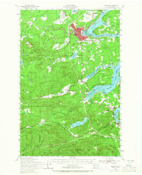
1953 Map of Shelton
USGS Topo · Published 1956About this map
Oakland Bay and its complex network of inlets define this mid-century view of Mason County. The city of Shelton serves as the industrial and logistical hub, where the Northern Pacific railroad meets the waterfront at Hammersley Inlet. North of the city, the Naval Auxiliary Air Station and Naval Reservation mark the military's footprint on Johns Prairie.
Find a feature on this map
85 named features on this map. Tap any name to fly to it.
Don’t see what you’re looking for? This feature index may not catch every label — zoom into the map to look around manually.
Map Details
Editions of this 1953 Shelton Map
2 editions found
Other maps of this area

1916 · Chehalis
USGS Topo · 1:125,000

1937 · Olympia
USGS Topo · 1:62,500

1938 · Allyn
USGS Topo · 1:62,500

1939 · Shelton
USGS Topo · 1:62,500

1940 · Tenino
USGS Topo · 1:62,500

1941 · Gate
USGS Topo · 1:62,500

1941 · Ford
USGS Topo · 1:62,500

1943 · Potlatch
USGS Topo · 1:62,500

1943 · Nahwatzel Lake
USGS Topo · 1:62,500

1944 · Tenino
USGS Topo · 1:62,500