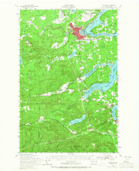
1953 Map of Shelton
USGS Topo · Published 1965About this map
Shelton serves as the industrial and logistical anchor for this region of Mason County, where the southern reaches of Puget Sound meet the timberlands of the Capitol State Forest. The map illustrates a landscape defined by deep-water inlets including Oakland Bay, Hammersley Inlet, and Skookum Inlet, which facilitated the transport of timber and maritime commerce. The presence of the Naval Auxiliary Air Station and a Naval Reservation highlights the strategic importance of the shoreline during the mid-century. Away from the saltwater, small agrarian and timber communities like Dayton and Kamilche are connected by the Northern Pacific railroad and early thoroughfares like Matlock Road. Local social life is evidenced by Reed HS, Grange Hall, and the Boy Scout Camp near Summit Lake, while the numerous sawmills and gravel pits suggest a resource-driven economy transitioning into the post-war era.
Find a feature on this map
79 named features on this map. Tap any name to fly to it.
Don’t see what you’re looking for? This feature index may not catch every label — zoom into the map to look around manually.
Map Details
Editions of this 1953 Shelton Map
2 editions found

Other maps of this area

1916 · Chehalis
USGS Topo · 1:125,000

1937 · Olympia
USGS Topo · 1:62,500

1938 · Allyn
USGS Topo · 1:62,500

1939 · Shelton
USGS Topo · 1:62,500

1940 · Tenino
USGS Topo · 1:62,500

1941 · Gate
USGS Topo · 1:62,500

1941 · Ford
USGS Topo · 1:62,500

1943 · Potlatch
USGS Topo · 1:62,500

1943 · Nahwatzel Lake
USGS Topo · 1:62,500

1944 · Tenino
USGS Topo · 1:62,500