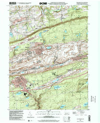
1999 Map of Shenandoah
USGS Topo · Published 2002About this map
The northern anthracite coal fields of Schuylkill County dominate this landscape, where the urban density of Shenandoah and Mahanoy City contrasts with the industrial scars of the surrounding ridges. Post-war mapping efforts here highlight a complex network of extraction and transit, notably the Mahanoy Plane and numerous mining junctions like Bear Run Jet and Wetherill Jet. The area's genealogical depth is visible in its religious and community landmarks, from the Old White Ch in Ringtown Valley to the St Joseph Cem and Union Cem.
Find a feature on this map
86 named features on this map. Tap any name to fly to it.
Don’t see what you’re looking for? This feature index may not catch every label — zoom into the map to look around manually.
Map Details
Editions of this 1999 Shenandoah Map
This is the sole edition of this map. No revisions or reprints were ever made.
Other maps of this area

1889 · Catawissa
USGS Topo · 1:62,500

1889 · Pottsville
USGS Topo · 1:62,500

1891 · Pottsville
USGS Topo · 1:62,500

1892 · Catawissa
USGS Topo · 1:62,500

1892 · Mahanoy
USGS Topo · 1:62,500

1892 · Pine Grove
USGS Topo · 1:62,500

1893 · Mahanoy
USGS Topo · 1:62,500

1894 · Catawissa
USGS Topo · 1:62,500

1944 · Pottsville
USGS Topo · 1:24,000

1944 · Orwigsburg
USGS Topo · 1:24,000