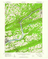
1955 Map of Shickshinny
USGS Topo · Published 1960About this map
Shickshinny Mountain and Penobscot Mountain frame the deep gorge of the Susquehanna River in this mid-century portrait of Luzerne County. The landscape is defined by its industrial and social density, particularly in the coal-rich eastern portion where settlements like Glen Lyon, Mocanaqua, and Alden are linked by a complex rail network including the Pennsylvania RR and the Central RR of New Jersey. The map documents a transition in transportation, noting the Delaware Lackawanna and Western RR (Abandoned Canal) following the river's path.
Find a feature on this map
137 named features on this map. Tap any name to fly to it.
Don’t see what you’re looking for? This feature index may not catch every label — zoom into the map to look around manually.
Map Details
Editions of this 1955 Shickshinny Map
This is the sole edition of this map. No revisions or reprints were ever made.
Other maps of this area

1889 · Catawissa
USGS Topo · 1:62,500

1889 · Hazleton
USGS Topo · 1:62,500

1891 · Wilkesbarre
USGS Topo · 1:62,500

1891 · Hazleton
USGS Topo · 1:62,500

1891 · Harveys Lake
USGS Topo · 1:62,500

1892 · Catawissa
USGS Topo · 1:62,500

1892 · Mahanoy
USGS Topo · 1:62,500

1893 · Hazleton
USGS Topo · 1:62,500

1893 · Harvey Lake
USGS Topo · 1:62,500

1893 · Pittston
USGS Topo · 1:62,500