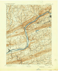
1894 Map of Shickshinny
USGS Topo · Published 1937About this map
The Susquehanna River carves a deep path through the Ridge and Valley Appalachians in this late 19th-century survey, revealing a landscape defined by industrial transport and anthracite-region coal towns. The map documents the overlap of two eras: the Pennsylvania Canal still follows the riverbanks while a dense network of railroads, including the Delaware Lackawanna and Western R.R. and the Central Railroad of New Jersey, powers the local economy.
Find a feature on this map
79 named features on this map. Tap any name to fly to it.
Don’t see what you’re looking for? This feature index may not catch every label — zoom into the map to look around manually.
Map Details
Editions of this 1894 Shickshinny Map
6 editions found


Other maps of this area

1889 · Catawissa
USGS Topo · 1:62,500

1889 · Hazleton
USGS Topo · 1:62,500

1891 · Wilkesbarre
USGS Topo · 1:62,500

1891 · Hazleton
USGS Topo · 1:62,500

1891 · Harveys Lake
USGS Topo · 1:62,500

1892 · Catawissa
USGS Topo · 1:62,500

1892 · Mahanoy
USGS Topo · 1:62,500

1893 · Hazleton
USGS Topo · 1:62,500

1893 · Harvey Lake
USGS Topo · 1:62,500

1893 · Pittston
USGS Topo · 1:62,500