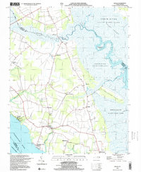
1999 Map of Shiloh
USGS Topo · Published 2003About this map
The North River and the Pasquotank River define this coastal landscape on the Albemarle Peninsula, where vast wetlands meet established rural communities. Settlement centers like Shiloh and Indiantown are connected by a network of roads that navigate around the Great Swamp and Run Swamp. The map details a landscape deeply tied to the water, featuring Elizabeth City Beach and Taylors Beach along the Pasquotank, while the Intracoastal Waterway cuts through the southwestern corner. Inland, the presence of numerous small Cem sites and the New Shiloh Ch reflect the area's genealogical depth. Land use is a mix of agricultural fields, sandpits, and large protected areas, notably the State Game Land surrounding the tidal reaches of the North River and its tributaries like Indiantown Creek and Bullfrog Creek.
Find a feature on this map
35 named features on this map. Tap any name to fly to it.
Don’t see what you’re looking for? This feature index may not catch every label — zoom into the map to look around manually.
Map Details
Editions of this 1999 Shiloh Map
This is the sole edition of this map. No revisions or reprints were ever made.
Other maps of this area

1940 · Barco
USGS Topo · 1:62,500

1940 · Powells Point
USGS Topo · 1:62,500

1940 · Wade Point
USGS Topo · 1:62,500

1943 · Wade Point
USGS Topo · 1:62,500

1946 · Eastville
USGS Topo · 1:250,000

1946 · Currituck Sound
USGS Topo · 1:250,000

1948 · Wade Point
USGS Topo · 1:62,500

1948 · Elizabeth City
USGS Topo · 1:62,500

1953 · Norfolk
USGS Topo · 1:250,000

1961 · Eastville
USGS Topo · 1:250,000