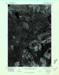
1975 Map of Shin Pond NE
USGS Topo · Published 1980About this map
The Seboeis River winds through this heavily forested landscape in northern Penobscot County, shown here in an orthophotomap format that emphasizes the dense vegetation and water drainage patterns of the Maine woods. Captured in the autumn of 1975, the imagery reveals the intricate, serpentine course of the river as it moves through marshy lowlands and timberland. Aside from a lone Brook and the primary river, the map is defined by its lack of named settlements, highlighting the remote and undeveloped character of the Maine backcountry during this period. The varying textures in the photography provide an overhead record of forest management and natural forest structure, offering a clear look at the terrain before modern digital mapping techniques transformed the way these remote timber lands were surveyed.
Find a feature on this map
2 named features on this map. Tap any name to fly to it.
Don’t see what you’re looking for? This feature index may not catch every label — zoom into the map to look around manually.
Map Details
Editions of this 1975 Shin Pond NE Map
This is the sole edition of this map. No revisions or reprints were ever made.
Other maps of this area

1940 · Island Falls
USGS Topo · 1:62,500

1940 · Oxbow
USGS Topo · 1:62,500

1942 · Island Falls
USGS Topo · 1:62,500

1942 · Oxbow
USGS Topo · 1:62,500

1954 · Shin Pond
USGS Topo · 1:62,500

1954 · Grand Lake Seboeis
USGS Topo · 1:62,500

1954 · Presque Isle
USGS Topo · 1:250,000

1958 · Presque Isle
USGS Topo · 1:250,000

1960 · Presque Isle
USGS Topo · 1:250,000
1965 · Oxbow
USGS Topo · 1:62,500