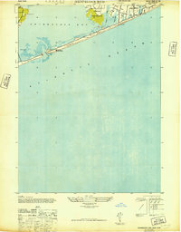
1947 Map of Shinnecock Bay
USGS Topo · Published 1947About this map
The village of Southampton and the Shinnecock Indian Reservation sit at the center of this coastal study, showing the South Shore of Long Island during the late 1940s. The landscape is defined by the thin barrier of Hampton Beach, which separates the Atlantic from the tidal waters of Shinnecock Bay. This era predates heavy modern development, showing the proximity of the Shinnecock Coast Guard Sta to the volatile Shinnecock Inlet. Inland, freshwater and brackish features like Agawam Lake and Cooper Neck Pond neighbor established local landmarks, including St Andrews Ch. The map illustrates a maritime-dependent community where small marshes and creeks, such as Heady Creek and Taylor Creek, dominate the interface between the village and the bay, providing a clear record of the coastline before major 20th-century shifts.
Find a feature on this map
15 named features on this map. Tap any name to fly to it.
Don’t see what you’re looking for? This feature index may not catch every label — zoom into the map to look around manually.
Map Details
Editions of this 1947 Shinnecock Bay Map
This is the sole edition of this map. No revisions or reprints were ever made.
Other maps of this area

1903 · Sag Harbor
USGS Topo · 1:62,500

1903 · Riverhead
USGS Topo · 1:62,500

1904 · Sag Harbor
USGS Topo · 1:62,500

1904 · Riverhead
USGS Topo · 1:62,500

1943 · Riverhead
USGS Topo · 1:62,500

1946 · Sag Harbor
USGS Topo · 1:24,000

1947 · Mattituck
USGS Topo · 1:24,000

1947 · Southampton
USGS Topo · 1:24,000

1947 · Quogue
USGS Topo · 1:24,000

1949 · New York
USGS Topo · 1:250,000