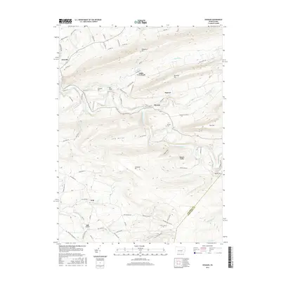
2016 Map of Shumans
USGS Topo · Published 2016About this map
Catawissa Creek carves a deep path through the coal-region ridges of Columbia County, separating Nescopeck Mtn to the north from the high elevations of Catawissa Mtn and McCauley Mtn. The landscape is defined by its narrow valleys and steep summits, with settlements like Shumans and Mainville clustered along the water and rail corridors. Small upland communities, including Mifflin Cross Roads and Dogtown, occupy the rare level stretches between the peaks. The map reveals a network of rural connections such as Scotch Valley Dr and Long Hollow Rd that link isolated farmsteads and historic family sites like Michaels Cem. This 2016 survey documents a region where the topographical constraints of the Pennsylvania mountains continue to shape the distribution of small towns like Beaver Valley and Mill Grove, preserving the traditional spatial patterns established over generations.
Find a feature on this map
75 named features on this map. Tap any name to fly to it.
Don’t see what you’re looking for? This feature index may not catch every label — zoom into the map to look around manually.
Map Details
Editions of this 2016 Shumans Map
This is the sole edition of this map. No revisions or reprints were ever made.
Other maps of this area

1889 · Catawissa
USGS Topo · 1:62,500

1892 · Catawissa
USGS Topo · 1:62,500

1892 · Mahanoy
USGS Topo · 1:62,500

1893 · Mahanoy
USGS Topo · 1:62,500

1894 · Catawissa
USGS Topo · 1:62,500

1894 · Shickshinny
USGS Topo · 1:62,500

1894 · Bloomsburg
USGS Topo · 1:62,500

1946 · Berwick
USGS Topo · 1:31,680

1947 · Bloomsburg
USGS Topo · 1:24,000

1947 · Ashland
USGS Topo · 1:24,000
Featured Places
- Locust Township, PA
- Main Township, PA
- Dogtown, Beaver Township
- Mifflin Cross Roads, Beaver Township
- Beaver Township, PA